Two years ago the Ministry of Environment (Minam) launched the implementation of adaptation measures to climate change (IMACC) project in the basins of Alto Mayo, San Martin, and the Quillcayhuanca sub basin in Ancash. At a cost of a million dollars the project was implemented with various institutions in both regions to look into the recovery of wetlands near Palcacocha Lake, as well as the modeling of a possible flood of glacial retreat in the lake of Palcacocha.
Every citizen in Huaraz knows about the possible danger of Lake Palcacocha, including the authorities. Local newspapers, radio and television stations; however, prefer not to report on this delicate topic. Why? It’s believed by local people that if the media were to speak about it people would get scared and tourists might flee from the city. Others admit that there is no real danger, little do they know about the precarious situation. There are; however, people who are seriously concerned and confirm that something has to be done before it’s too late. The reason for us writing about this topic is because public safety is at risk. A second reason is because the Centre for Research in Water Solutions, together with the Bureau of Engineering Research of the University of Texas published a very interesting online report in March of this year presenting the inundation modeling of a potential glacial lake outburst flood in Huaraz.
Are we really waiting to close the stable door after the horse has bolted? In other words, why wait for a possible outburst when the problem has been analysed and identified, and solutions are available. A month ago the municipal manager of Huaraz, Carlos Tarazona, who is also running for mayor in the forthcoming elections, confirmed on local TV Channel Three that the situation is completely under control. He was pointing to the fact that the lake is being kept under surveillance. When asked whether he was referring to the guard who was permanently stationed at the lake with an old radio phone Tarazona confirmed that this was the case, also admitting that this is probably not enough and that more could (rather should) be done to monitor the situation. Summarised, it basically means that the lives of the 120,000 citizens of Huaraz and Independencia depend on one person. If this one person, who apparently is in constant contact with the National Park in Huaraz, is unable make the frightening phone call for whatever reason, people have a little over one hour to evacuate. This is confirmed by the Centre for Research in Water Solutions in a report written by Marcelo A. Somos-Valenzuela, Rachel E. Chisolm, Daene C. McKinney and Denny Rivas of the Centre for Research in Water Solutions.
What follows is an excerpt from the report on the inundation modeling of a potential glacial lake outburst flood in Huaraz. It describes an analysis of the processes involved, the behaviour and consequences of a potential Glacial Lake Outburst Flood (GLOF) from Lake Palcacocha, and the resulting inundation in Huaraz. The process starts with an avalanche falling into the lake, resulting in a wave that overtops the moraine causing a breach thus ensuing downstream flooding and inundation in the city of Huaraz. Not all passages of the report are published as some contain some very difficult calculations such as the Governing Equation of Mass Conservation, the Prediction of Wave Height as well as Roughness Coefficient Values are, among others, left out of this article to keep is more or less readable. People who are interested looking up the complete report can find it online at crwr.utexas.edu/online.shtml.
Lake Palcacocha poses an increasing glacial lake hazard in the Cordillera Blanca. In 1941 a GLOF occurred from the lake that flooded the city of Huaraz, killing more than 5,000 people (according to best estimates) and destroying infrastructure and agricultural land all the way to the coast (Carey 2010). In recent years, Lake Palcacocha has grown to the point where it is once again dangerous. Avalanches from the steep surrounding slopes can now reach the lake directly, creating the potential for generating waves that could overtop the moraine dam and reach the city of Huaraz (Hegglin and Huggel 2008). In 2010, the lake was declared to be in a state of emergency because its level exceeded the height deemed safe (Diario la Republica 2010). Siphons have been installed at the lake recently to temporarily lower the water surface about three metres, but lowering it 15 m or more is recommended for safety now and in the future (Portocarrero 2014). The lake’s damming moraine could possibly fail if an avalanche generated wave overtops the moraine and abruptly releases a large volume of water from the lake creating a flood wave and/or debris flow (Instituto Nacional de Defensa Civil 2011). Local authorities and people living in Huaraz are concerned about the threat posed by Lake Palcacocha, and they have requested technical support to investigate the impacts that a GLOF could have on Huaraz and methods to reduce the risk.
Study area
Lake Palcacocha is located at 9°23′ S, 77°22′ W at an elevation of 4,562 m in the Ancash Region of Peru and is part of the Quillcay watershed in the Cordillera Blanca. The lake has a maximum depth of 73 m and an average water surface elevation of 4562 m. The outlet of the lake flows into the Paria River, a tributary of the Quillcay River that passes through the city of Huaraz to the Santa River, the main river of the region. Prior to the 1941 GLOF, the lake had an estimated volume of 10 to 12 million m3 of water (Instituto Nacional de Defensa Civil 2011). After the 1941 GLOF, the volume was reduced to about 500,000 m3. In 1974, drainage structures were built at the lake to maintain 8 m of freeboard at the lake outlet, a level thought to be safe from additional avalanche generated waves. Due to the growth of the lake in the up-glacier direction, the lake volume increased to about 17 million m3 of water by 2009, exceeding the level that is safe (Instituto Nacional de Defensa Civil 2011). The siphon system has been able to reduce the level of the lake by 3-5 m providing a total free board of about 12 m.
Methodology
The report considers a chain of events that could result in an avalanche- triggered GLOF from Lake Palcacocha and assess the potential flooding of Huaraz from such an event. The assumed trigger for the GLOF is an avalanche from the Palcaraju or Pucaranra glaciers located directly above the lake. Three different avalanches sizes are considered: small (0.5 million m3), medium (1 million m3) and large (3 million m3). When the avalanche enters the lake, the resulting wave can overtop the damming moraine, which has 8-12 m of freeboard, and initiate an erosive breaching process that could release considerable amounts of water to the Paria River and potentially flood densely populated areas of Huaraz. The process chain from avalanche to inundation was simulated using several models: potential avalanches were modelled using RAMMS (Christen et al. 2010), lake-wave dynamics were modeled with FLOW-3D (Flow Science 2012), hydrographs of the potential GLOF discharge from the moraine breach were generated using MIKE-11 (DHI 2001), and propagation of the flood wave downstream and inundation in Huaraz were calculated using FLO-2D (O’Brien 2003).
Different executions and calculations of simulations
The researchers used an exclusively 5 m x 5 m horizontal resolution digital elevation model (DEM) for this work (Horizons 2013) using high-resolution Laser Imaging, Detection and Ranging (LIDAR) techniques, which provide vertical accuracies of up to 7 cm. A set of ten Ground Control Points (GCP), temporarily established to support the LIDAR flights, allowed control, calibration and adjustment of the LIDAR data, and orthocorrection of high-resolution aerial images. A drainage line dataset created by the Geographic-Military Institute of Peru was used to verify the DEM information and provide the streamline of the Paria River, which drains from Lake Palcacocha as well from the Quillcay, and Rio Santa streamlines. The Unidad de Glaciologia y Recursos Hidricos of Peru’s National Water Authority (UGRH) carried out a bathymetric survey of Lake Palcacocha in 2009 that was used to represent the elevation of the lake bottom in the DEM (UGRH 2009). The original document also demonstrates calculations of an avalanche simulation, a lake simulation when the avalanche (100% chance) hits the lake, a moraine breach simulation, hazard identification and an inundation simulation of Huaraz.
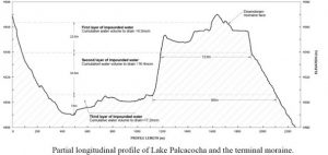
Moraine breach model
There is no data of an actual breaching event to compare the results of the simulations with or calibrate the model. Instead, the simulation has two objectives: (1) to reasonably validate the peak flow and failure time values estimated by the empirical equations, and (2) to produce the hydrographs that those empirical equations are not able to provide. Because the investigators lacked the precise geotechnical and erosion characteristics of the Lake Palcacocha moraine, they followed two main criteria to define the potential shape and depth of the breach. First, they assumed that the easiest path for water to flow through will be the path defined by the 1941 GLOF. That breach remains and it seems reasonable that a new flood will flow in the same way as the 1941 flood. Secondly, though the breach`s depth may vary somewhat, due to the magnitude and continuity of the trigger mechanism (avalanche generated wave overtopping), the worst-case event is the most appropriate scenario for planning possible mitigating measures (Laenen et al. 1987). Likewise, in the absence of bedrock and given the presence of low cohesion materials are unlikely to prevent large-scale breaches from forming in the Lake Palcacocha moraine (C. Portocarrero, 2013, personal communication). There is some uncertainty about the depth to bedrock at the moraine and the researchers had assumed two different levels of possible moraine erosion (56 m and 22.5 m, see graph on this page) as discussed below. The figure below shows the cross-section through the moraine based on the lake bathymetry and the DEM. The profile in the figure also shows three elevation layers associated with different moraine dimensions and impounded water volumes. The surface of the upper layer (0-22.5 m depth) is immediately exposed to erosion, and it is comprised of materials with less cohesive properties that increase its susceptibility to failure. In order to reach the bottom of the second layer, the breach must go to a depth of 56 m, longitudinally erode over 985 m of moraine material, and be able to drain 16.4×10⁶ m3 of water. There are no estimates of the probability of the latter event, but uncertainty on internal conditions of the moraine structure does not allow us to reject the hypothesis that such an event might actually happen. Therefore, two potential breaches have been considered due to a large avalanche event and associated wave: one that erodes the moraine to a breach depth of 56 m and a smaller one that has a breach depth of 22.5 m. The breach depth of 56 m is the worst-case scenario. If the third layer of the moraine were to be exposed, a relatively small volume of water would remain: 0.8×10⁶ m3 or about 5% of the entire water volume. To release that volume, which the investigators consider very unlikely, over 1700 m of moraine material must be eroded in the longitudinal direction, extending the breach 700 m longer than the length developed in the second layer. For the 56 and 22.5 m breaches, the depth of the water is not equal to the depth of the breach since the latter includes the freeboard at the top part of the moraine above the invert of the drainage structure. The difference is 6.3 m because the overtopping wave discharge does not include the entire avalanche volume, 0.5×10⁶ m3 of the wave volume is retained in the lake and 2.5×10⁶ m3 is released in the overtopping discharge. Therefore, the residual lake volume increases both the volume (by 0.5×10⁶ m3) and depth of the lake (by 1.7 m) before the erosive process starts. In the overtopping, they assume that the top part of the moraine (8 m above the drainage tunnel invert level) is instantaneously destroyed. The erosion rate is uniformly distributed below that level. The volume of impounded water released in the breaching process increases once the wave passes through the lake. The figure shows static conditions before the chain of processes starts.
![]()
Results of simulations
The resulting maximum flood depth within Huaraz for the 22.5 m event is shown on the front page of The Huaraz Telegraph. The deepest areas are near the existing channels of the Quillcay River and the Rio Santa. The highest inundation depths occur at the south side of the river, where most of the commerce is located in Huaraz. Considering the 56 m breach event, within the city, the area where the depths are small (<1 m) is limited to 0.13 km2 in a narrow band ranging from 20 to 60 metres in width along the outskirts of the flooded area. The area flooded to a depth between 0.2-1 m covers an area of 0.51 km2 and the area flooded to depths greater than 1 m covers an area of 4.5 km2. The area near the channel of the Quillcay River shows depths of 5-10 m in a band approximately 350 m wide in the east side of the city and up to 500 m wide in the west side of the city near the Santa River. In comparing the two events, one can see that areas that had inundation depths of 1-2 m in the 56 m breach have depths of 0.1-1 m in the 22.5 m event. Similarly areas that show 4-6 m depth in the 56 m event reduce to 3-4 m depth in the 22.5 m event, and 8-10 m depth areas reduce to 6-8 m depth in the 22.5 m breach event. Considering the 56 m breach event, within the city, velocities in excess of 8 m/s occur only in the narrow river channel in the canyon and in small isolated areas in the city. Velocities between 5-8 m/s occur in the areas where the inundation depths are between 5-10 m. In the outer area velocities of 0–2 m/s occur in areas with depths lower than 5 m. Velocity reductions for the 22.5 m breaching event, compared to the 56 m event, follow the same pattern as the inundation depths discussed above.
Conclusions
The chain of events that would be triggered by an avalanche into Lake Palcacocha was simulated to assess the level of hazard for the city of Huaraz. Avalanche simulations were carried out to determine the height and velocity of the avalanche material entering the lake and it showed an avalanche height of 20m and a velocity of 50 m/s entering the lake. A three-dimensional hydrodynamic lake model was used to simulate the movement of the resulting impulse wave across the lake and the overtopping of the terminal moraine. The overtopping wave discharge hydrograph released a volume of 2.4×10⁶ m3 of water. The moraine erosion resulting from the overtopping was simulated to provide a combined hydrograph of the released water and debris. Two scenarios of moraine erosion were simulated: a worst-case event of a 56 m breach and a smaller 22.5 m erosion event. The combined discharge hydrograph released a volume of 19.8×10⁶ m3 for the 56 m event and 12.3×10⁶ m3 for the 22.5 m event. These hydrographs were used as input to a two-dimensional flood model (water and debris), and the hydrographs was routed downstream reaching the city of Huaraz 1.06 and 1.20 hours after the avalanche for the 56 m and 22.5 m events, respectively. The inundation in the city is extensive in both breaching events with depths exceeding 1 m in many areas, especially near the channel of the Quillcay River, and the velocity of the flood exceeding 1 m/s in most of this area. Because of the inundation depth and the velocity of the flow, most of the area of the city that experiences flooding will have a very high hazard level, putting both lives and properties at risk.
Should history repeats itself and according to calculations a possible flood would cause much worse disasters compared to the one in 1941 – something really no one hopes for. There would probably be many fingers pointing towards the local authorities who would no longer be able to say: ¨Wir haben es nicht gewußt.¨ It´s time to undertake action, rather sooner than later.
All credits to the original authors of the document; Marcelo A. Somos-Valenzuela, Rachel E. Chisolm, Daene C. McKinney and Denny Rivas of the Centre for Research in Water Solutions.